

ZIMAS is free, official, and genuinely powerful – for Los Angeles. Here’s what developers need when they work beyond city limits, or need AI that actually interprets the data.
The Zone Information and Map Access System is the City of LA’s official zoning tool – free, publicly available, built and maintained by LA City Planning. And it’s more capable than most people realize. But there’s one thing ZIMAS cannot do – and for developers working across multiple markets, it’s the only thing that matters.
1. What ZIMAS Actually Does
For any parcel inside Los Angeles city limits, ZIMAS surfaces:
Planning and Zoning
- Zoning designation – base zone, height district, and all overlay conditions ([Q], CDO, HPOZ, CPIO)
- General plan land use, specific plan area, Zoning Information links (Transit Priority Areas, Housing Element Sites, Community Design Overlays, CPIO, State Enterprise Zones)
- Historic Preservation Review, HistoricPlacesLA designation, and dozens of additional overlay flags (Hillside Construction Regulation, NSO, POD, RIO, RFA, Clean Up-Green Up, Sign District, and others)
Incentive Eligibility
- Transit Oriented Communities (TOC) tier, AB 2097, AB 2011, AB 130, SB 9, SB 35, SB 684 – eligibility links for each
- Downtown Adaptive Reuse Program, Mixed Income Incentive Programs (TOIA, Opportunity Corridors, Corridor Transition), TCAC Opportunity Area, ED 1 Eligibility, High Quality Transit Corridor
- Inclusionary Housing requirements, Local Affordable Housing Incentive, Urban Agriculture Incentive Zone, Redevelopment Project Area
Housing Policy
- Rent Stabilization Ordinance (RSO), Ellis Act, Just Cause for Eviction (JCO)
- Housing Crisis Act review, Housing Element Sites data (HE Replacement Required, SB 166 Units), Housing Use within Prior 5 Years
Hazard Data
- Seismic Hazards — nearest fault name and distance (km), fault type, slip rate, slip geometry, maximum magnitude, Alquist-Priolo Fault Zone status
- Liquefaction, landslide, tsunami; Methane Hazard Site designation; Flood Zone; Very High Fire Hazard Severity Zone; WUI; High Wind Velocity; Sea Level Rise; Oil Well Adjacency
- Environmental screening – Biological Resource Potential, Mountain Lion and Monarch Butterfly Potential, 300-Foot Habitat Buffer, USFWS-designated CHAs, Criterion 1 PAWs, and others
- Airport Hazard, Coastal Zone, Coastal Bluff Potential, Canyon Bluff Potential
Assessor, Planning History, and Administrative Data
- Assessed land value and improvement value, last sale amount and date, APN area, use code, deed reference numbers, building data
Note: owner name and address are not available in the public internet version of ZIMAS.
- Every CPC, ORD, ENV, and CHC case tied to the parcel, going back decades
- Community Plan Area, Area Planning Commission, Neighborhood Council, Council District, Census Tract, LADBS District Office, Public Safety data, parking and school/park zone flags
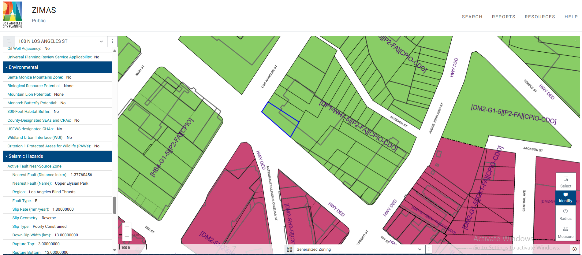
This is not a basic lookup tool. For a parcel in Downtown LA, ZIMAS surfaces well over a hundred data points across zoning, incentives, hazards, housing policy, environmental conditions, and planning history.
ZIMAS is a powerful, free public resource. It was built for Los Angeles and it serves that purpose exceptionally well. The problem is the first four words of that sentence.
2. The Two Things ZIMAS Cannot Do
Work outside Los Angeles city limits
ZIMAS only covers the City of Los Angeles. Not LA County. Not Culver City, Santa Monica, Long Beach, Glendale, Pasadena, Burbank, or any of the 87 other incorporated cities in LA County – let alone the rest of California or the United States. For a developer evaluating sites across multiple markets, ZIMAS is a dead end the moment a site falls outside LA city limits.
Interpret the data it shows
ZIMAS shows data. It does not interpret it.
You see “Methane Buffer Zone: Yes.” ZIMAS cannot tell you what that means for your project – whether it affects financing, what mitigation costs look like, or how it interacts with other constraints on the site.
You see zoning [DF1-WH1-5][P2-FA][CPIO-CDO]. ZIMAS cannot answer: “Given this zoning, can I build 80 units of workforce housing here, and what approvals would I need?”
That’s the gap. Not data – interpretation. And not just for LA – for every market in the US.
3. The Alternatives at a Glance
| Tool | Coverage | Data Depth | Interprets Data | AI Chat | Site Screening | Ownership | Price |
| ZIMAS | LA city only | Comprehensive | No | No | Map layers only | No (public) | Free |
| Zoneomics | 20,000+ US cities | Zoning + land use | Basic | Basic | Yes | No | Paid |
| General AI | General knowledge | No live data | General | General | No | No | Free/Paid |
| Claude | General knowledge | No live data | Strong | Strong | No | No | Free/Paid |
| Archiwise | US nationwide | Full | Yes | RAG-powered | Yes | Yes | Paid |
4. The Alternatives in Detail
Zoneomics
Zoneomics covers over 20,000 municipalities across the US – zoning designations, permitted land use filtering, FAR data, height controls, and a site selection tool for searching across multiple cities. Their Bassett AI assistant answers general zoning questions.
Best for: Teams needing zoning data across multiple cities or API access for custom workflows.
What it does not cover: Hazards, housing policy, incentive screening, or assessor data. Bassett AI answers general questions but does not provide parcel-specific answers cited to governing planning documents. No multi-parcel analysis.
General AI – ChatGPT, Gemini, and similar
Best for: Understanding zoning concepts, plain-language explanations, drafting questions for a planning department.
The limitation: No access to live parcel data, current incentive databases, hazard designations, or planning case history. Answers reflect training data, not current conditions.
Claude
Claude reads and analyzes planning documents you share with it, explains zoning designations in plain language, reasons through entitlement paths, and drafts application narratives and responses to planning department comments.
Best for: Analyzing documents you already have, reasoning through edge cases, drafting entitlement narratives and community outreach materials.
The limitation: No live data access. Cannot look up current zoning, TOC eligibility, assessed value, or hazard status for a specific parcel. Works only from what you provide.
Archiwise
Archiwise is an AI decision platform for real estate pre-development – covering any parcel in the United States.
The platform brings together zoning, hazards, incentives, value, ownership, demographics, infrastructure context, and AI interpretation in one place. It is built to help developers answer the questions that come up on every site:
- What can we build here?
- Where should we build?
- Is this a good place to build?
- Does it pencil?
- How likely is it to get approved?
These are not simple questions. Each one requires zoning analysis, hazard screening, incentive eligibility, market context, and an understanding of the entitlement process – for a specific parcel, in a specific jurisdiction. Archiwise brings that together in one place, for any parcel in the US.
That makes it useful across the full range of pre-development situations:
- Deciding whether to pursue a site – zoning, incentive profile, hazard conditions, ownership, and assessed value in one place, with AI interpretation of what those factors mean for development
- Assemblage analysis – load up to five parcels simultaneously; the AI reasons through combined FAR, total unit potential, conflicting zoning conditions, and what the assembled site could support
- Lot split and subdivision – ask the AI whether a parcel qualifies for SB 9, what the minimum lot dimensions require, and what each resulting parcel could support independently
- Early feasibility – before engaging a consultant, get a first-pass read on what can be built, what approvals are needed, what incentives apply, and what the hazard picture looks like
- Site selection across markets – screen parcels by lot size, zoning, vacancy, value, proximity, and demographics across a drawn search area nationwide
Info Modal
Every parcel opens an info modal with a scrollable set of seven data tabs – Records, Incentives, Zoning, Value, Hazards, Ownership, and Demographics – plus Street View thumbnails and an Ask AI button.
At the top of the modal, Archiwise automatically generates an AI summary card for every parcel, covering:
- Overview, Highest & Best Use, Development Potential, Key Constraints, and Financial Signal
This appears automatically on every parcel you open – a first-pass read before you go deeper into any tab or the AI Zoning Expert chat.
The Zoning tab goes beyond a simple code lookup:
- Zoning Code, Name, Type, Subtype, and a direct View Code link to the full zoning code text
- Permitted Land Uses: As of Right – explicitly listed
- Permitted Land Uses: Conditional – uses requiring discretionary approval, explicitly listed
- Prohibited Land Uses – what cannot be built or operated on this parcel, explicitly listed
This three-way breakdown – as of right, conditional, prohibited – is the difference between knowing a parcel’s zone code and understanding what you can actually do with the land.
The Ownership tab shows owner name, ownership type, and mailing address – data that ZIMAS’s public internet version explicitly withholds.
Map Layers
- Property Data: Boundaries, Parcels, Zoning (color-coded), Postal Codes, Frontage
- Infrastructure: Gas Pipeline, Electricity Lines, Sewer Lines
- Hazards: Fire Hazard Zones, Flood Hazard Zones, Fire Footprints, Earthquake Faults, Seismic Hazard, Methane Hazard Areas
- Housing Incentives, Historic Resources, Points of Interest, Topology
- Demographics: Median Household Income, Population Density, Median Rent, Rent Burden, Homeownership Rate, Age groups, Education, Poverty Rate, Labor Force, Unemployment, Six-Figure Households
The infrastructure layers – gas pipeline, electricity lines, sewer lines – have no equivalent in ZIMAS or Zoneomics.
Site Screening and Filtering
The Draw Search Area tool lets you define a custom polygon and screen every parcel within it by lot size, frontage, year built, vacancy, current use, value, ownership type, zoning, proximity to any point of interest, and demographic characteristics.
AI Zoning Expert
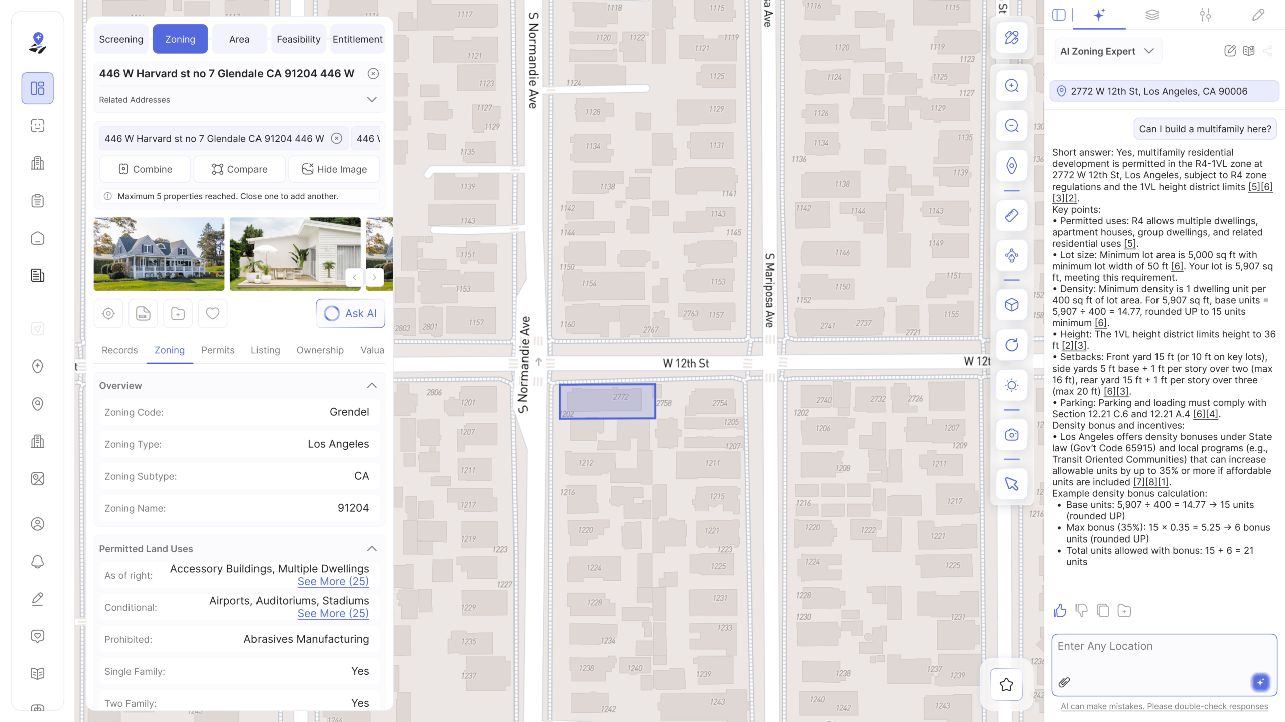
The AI Zoning Expert is a chat panel that opens alongside the parcel data. Ask a development question and it returns a structured, parcel-specific answer. Asking “Can I build a multifamily here?” returns:
- A direct yes or no with the zone cited, permitted uses, and density calculation using the actual parcel’s square footage
- Height limits, setback requirements, parking requirements with code section references
- Density bonus calculation – base units, bonus percentage, and total (e.g., 15 base + 6 bonus = 21 units)
- Numbered source citations – [5][6][3][2] – linking to the specific planning documents the answer draws from
The platform displays “AI can make mistakes. Please double-check responses” beneath every AI answer.
5. The Honest Comparison
ZIMAS is a remarkable free tool – more capable than most people realize. For developers working exclusively in Los Angeles city limits, it covers an enormous amount of ground.
The two things it cannot do:
Work outside Los Angeles. The moment your search crosses a city boundary, ZIMAS stops. Archiwise covers any parcel in the US.
Interpret the data. ZIMAS shows you that a site is in a Methane Buffer Zone, that the nearest fault is 1.38 km away, that the parcel carries a CPIO-CDO overlay. It cannot tell you what those conditions mean for your project. Archiwise can – with the source documents cited and the calculation shown.
6. When to Stick with ZIMAS
- You work exclusively in LA city limits. The geographic limitation does not apply – and the data depth is exceptional.
- You only need the raw data. If you can interpret zoning designations, hazard flags, and incentive eligibility yourself, ZIMAS gives you that for free.
- Budget is the constraint. ZIMAS is free, actively maintained by LA City Planning, and updated in early 2025 to reflect the new Chapter 1A zoning code.
7. When to Switch to Archiwise
If any of these questions come up on a site – and you are outside LA city limits – ZIMAS cannot answer them. Archiwise can.
What can we build here?
- You need to know what you can actually build – not just the zone code. As-of-right uses, conditional uses, and prohibited uses, interpreted for that specific parcel, with a direct link to the code and AI that works through the development capacity calculations.
- You evaluate sites outside LA city limits. Any parcel outside the City of LA – ZIMAS cannot help. Archiwise covers any parcel in the US.
Where should we build?
- You want to prospect for sites across markets. Screen by lot size, use, value, zoning, proximity, vacancy, and demographics across a drawn search area – nationwide.
- You are evaluating an assemblage. Load up to five parcels and ask the AI to reason through combined development potential, zoning conflicts, and what the assembled site could support.
Is this a good place to build?
- You need data interpreted, not just displayed. Zoning designations, hazard flags, incentive eligibility, assessed value – the AI explains what they mean for the specific site, with the governing planning documents cited.
- You want infrastructure context. Gas pipelines, electricity lines, and sewer lines on the map. ZIMAS has no equivalent.
- You need ownership information. ZIMAS’s public version withholds owner name and address. Archiwise shows owner name, ownership type, and mailing address.
Does it pencil?
- You need assessed value, last sale data, and improvement-to-land ratios alongside the zoning and incentive picture – in one place, for any US parcel.
- You are exploring a lot split or SB 9 scenario. Ask the AI Zoning Expert whether the parcel qualifies, what the minimum lot dimensions require, and what each resulting parcel could support.
How likely is it to get approved?
- You need to understand the entitlement path. What is by right, what triggers discretionary review, and what incentive programs could streamline the process – for that specific parcel, cited to the governing documents.
- You need early feasibility before engaging consultants. Get a first-pass read on what can be built, what approvals are needed, and what the constraints are – before spending on professional fees.
8. Frequently Asked Questions
Is ZIMAS being replaced?
No. ZIMAS is actively maintained by LA City Planning and was updated in early 2025 to reflect the new Chapter 1A zoning code. It remains a free public tool for Los Angeles only, with no AI interpretation layer.
Does Zoneomics cover Los Angeles?
Yes. Zoneomics covers over 20,000 municipalities including Los Angeles. It provides broader geographic coverage than ZIMAS but does not match the depth of hazard, housing policy, and incentive data that ZIMAS provides for LA specifically.
Can I use Claude for zoning research?
Yes – with clear expectations. Claude is capable for reasoning through zoning questions and analyzing documents you share with it. It has no access to live parcel data, current incentive eligibility, or real-time hazard information.
Can I use Archiwise outside California?
Yes. Archiwise covers parcels across the United States – any city, any state, any county.
What kinds of situations does Archiwise support?
Deciding whether to pursue a site. Assemblage analysis. Lot split and SB 9 feasibility. Site selection across markets. Early feasibility before engaging consultants. Any situation where you need to understand what can be built on a parcel, what it would take to get approved, and whether the numbers work – for any parcel in the US.
What makes Archiwise’s AI different from general AI tools?
Two things work together. First, Archiwise has built one of the largest collections of planning documents from city and county departments across the United States – zoning codes, specific plans, general plans, community plans, overlay ordinances, and state legislation covering jurisdictions nationwide. Second, the platform integrates extensive data layers – parcel data, ownership records, hazard designations, incentive boundaries, infrastructure networks, demographic data, and more – all mapped and linked to specific locations. When you ask about a parcel, the AI draws from both: the documents that govern that jurisdiction and the data that describes that specific site. That combination is what makes the answers parcel-specific and accurate for any city in the US, not just Los Angeles.
See what Archiwise surfaces for any parcel – in seconds.
Everything ZIMAS does, interpreted by AI, for every city in the US.
Learn more
ArchiWise helps developers, investors, architects, and brokers go from address to decision in minutes, not weeks.
Whether you’re screening sites for multifamily development, evaluating zoning constraints, surfacing incentive eligibility like QCT and LIHTC, or assessing hazard risk before committing capital, ArchiWise runs every layer of analysis in one place.
Explore how ArchiWise helps teams screen development sites, analyze zoning, and make confident go/no-go decisions faster.